China’s new Map:Cartographic desires
In the early morning of August 28, the international community was taken aback by an unexpected event that would have far-reaching consequences. China, known for its assertive stance on territorial claims, released its highly anticipated new standard map. However, what was meant to be a routine cartographic update quickly turned into a hotbed of controversy, stirring up tensions and raising questions about China's intentions. The aim of this article is to shed light on the new changes introduced by China and how they are expected to impact the interests of other countries.
What does China claim?
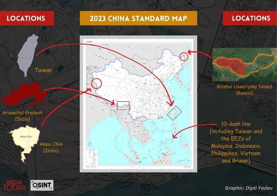
One of the most contentious changes introduced in the new map released by China was the incorporation of disputed territories within its borders. Notably, China claimed the Indian territories of Arunachal Pradesh and the Doklam Plateau, as well as Aksai Chin in the western section. By asserting its authority over these areas, China disregarded India's sovereignty and heightened tensions between the two nuclear-armed neighbours.
However, the impact of China's new map extended beyond India. In the South China Sea, an area rife with competing territorial claims, China made a significant alteration to its depiction of authority. Instead of the widely recognized nine-dash line, China now asserted a ten-dash line, expanding its claim to a larger portion of the resource-rich waters. This expansionist move not only heightened tensions with neighboring countries but also drew international criticism. China's revised map challenged the United Nations Convention on the Law of the Sea and undermined the territorial rights of other claimants in the region.
Furthermore, China's new map also included Bolshoy Ussuriysky Island, located at the confluence of the Amur and Ussuri rivers. Despite a previous agreement between China and Russia to divide the island, China's inclusion of it in its map suggested a reluctance to fully honour the agreement.
How have countries reacted?
The release of China's new standard map has triggered strong reactions from neighboring countries, leading to a flurry of diplomatic activity. Among the nations affected, India, already involved in a long-standing border dispute with China, strongly condemned the inclusion of Arunachal Pradesh and Aksai Chin. The Official Spokesperson of India's Ministry of Foreign Affairs, Shri Arindam Bagchi, lodged a protest on August 29, 2023, stating, “We reject these claims as they have no basis. Such steps by the Chinese side only complicate the resolution of the boundary question.” India's External Affairs Minister S Jaishankar added, “Just making absurd claims does not make other people's territories yours.”
Similarly, Malaysia's Ministry of Foreign Affairs stated on August 30, 2023, that it does not recognize China's claims in the South China Sea as depicted in the “Standard Map of China Edition 2023.” Indonesia's Foreign Minister Retno Marsudi stressed the importance of territorial lines being in accordance with the UN Convention on the Law of the Sea 1982.
In addition to these responses, Japan criticised China for its claims regarding the Senkaku Islands, stating that the new map violated Japan's territory under international law. Japan demanded an immediate withdrawal of the map. Meanwhile, Russia rejected the Chinese map, stating that the territory claimed by China had already been settled through an agreement.
Moreover, the spokesperson for Taiwan's Foreign Ministry, Jeff Liu, stated that Taiwan is not a part of China and that the Chinese government cannot change the fact of Taiwan's existence. The Philippines also rejected China's attempt to establish sovereignty and jurisdiction over Philippine features and maritime zones, stating that it has no basis in international law, specifically the UNCLOS. They called on China to act responsibly and adhere to its obligations under the UNCLOS and the 2016 Arbitral Award, which is final and binding. Furthermore, Vietnam criticized China's release of the new map, which includes islands claimed by Vietnam. Vietnam argued that these actions violate their sovereignty and rights under the UNCLOS, and that China's claims based on the dotted line on the map are null and void, going against international law.
These varied responses highlight the mixed international reaction to China's new map, reflecting the delicate balance of power in the region. While some countries strongly opposed China's revisionist approach, citing concerns over the violation of international norms and the potential for destabilization, others remained relatively silent, cautious about directly confronting China and risking damage to their diplomatic relations.
What does China have to say about the situation?
During a media briefing on August 30, 2023, a reporter from China Daily brought up the issue of India lodging a protest against China's release of standard maps, stating that it would complicate the resolution of border issues. The reporter asked for China's response to this criticism.
In response, Wang Wenbin, the spokesperson for China's Ministry of Foreign Affairs, explained that the release of the standard map by China's Ministry of Natural Resources on August 28 was a routine exercise of sovereignty in accordance with the law. He urged the relevant parties to view it objectively and avoid over-interpreting it.
Similarly, during a regular press conference on August 31, 2023, Wang Wenbin was asked by a Reuters reporter about the difference in the demarcation line on the 2023 map compared to the one submitted by China to the UN in 2009. Wang Wenbin reiterated China's consistent and clear position on the South China Sea, stating that the competent authorities of China routinely publish standard maps to raise public awareness of the standardized use of maps. He urged the concerned parties to view the maps objectively and rationally.
Implications
China's new standard map had far-reaching implications beyond cartography. It was a calculated and strategic move to legitimize its territorial ambitions and project global power. By redrawing boundaries and altering the depiction of disputed regions, China aimed to reshape the narrative and establish a new normative order that favored its territorial claims.
The publication of this map served as a means for China to assert its territorial claims and influence public opinion both domestically and internationally. However, it is crucial to note that map publication alone does not grant China the legal right to claim other territories. The international community recognizes that cartographic representations do not establish valid claims. Resolving territorial disputes requires a comprehensive examination of historical, legal, and political factors to determine the legitimacy of competing claims.
In response to China's revisionist approach, it is essential for the international community to uphold the principles of international law and adhere to established legal frameworks. Open dialogue, peaceful negotiations, and respect for the rights of all parties involved are critical in resolving territorial disputes. Maps alone cannot override these principles or alter the legal status of disputed territories.
Pic Courtsey-India Today
(The views expressed are thsoe of the author and do not represent views of CESCUBE.)